Location: Golden Circle (Geysir, Gulfoss, and Þingvellir)

One of the most popular tourist destinations of Iceland is a group of 3 spots within close proximity to each other which are collectively called "The Golden Circle." Located about 90 minutes away from Reykjavik, it is comprised of Geysir (same pronunciation as geyser, and is one of the few Icelandic words assimilated into English), Gulfoss, and Þingvellir. All 3 can be visited in a single afternoon, and they're easy to find because one only needs to follow the tour buses.
Geysir
Calling the area Geysir is actually a misnomer; technically it should be referred to as the Haukadalur geothermal area (which contains many geysers of various sizes). My guess is this was too difficult for tourists so they call the whole thing "Geysir" for simplicity. This probably used to make sense because Geysir is the name of what used to be the largest and most predictably erupting geyser. Unfortunately Geysir is no longer regularly active and just sits there, but the name remains. The current "star of the show" is Strokkur which erupts to a height of about 70 feet (20 meters) every 5-10 minutes. By comparison, Old Faithful in Yellowstone averages about 130 feet (40 meters) every 30-100 minutes. Geysir used to blow water as high as 260 feet (80 m); too bad I missed that show!
This is what the area looks like. FYI - this is a lot of tourists by Icelandic standards. The geyser in the photo is Strokkur (the current active one).
 And here it is when it starts to erupt...
 And it keeps going...
 I was lucky to get a picture with it erupting. Many thanks to my photographer who was forced to remain poised for several minutes.

Gulfoss
This is one of the largest and most breathtaking waterfalls in the country. Here's a shot from up above looking down into the valley. Notice how small the people along the trail and the ridge on the left-hand side look.
 The view if you turn around while coming down the trail. The previous picture was taken pretty close to where those people on the ledge are standing.
 And this is what it looks like if you get a closer look at the falls.
 More of the good stuff.
 As usual, proof that I was actually there...
Þingvellir (pconounced Thing-vellir)
This is arguably the most important historic site in the country. Iceland likes to brag it houses one of the oldest parliaments in the world, and Þingvellir is where all the ancient people met annually starting in 930 AD. All kinds of disputes and duels were settled, and criminals were also punished. Supposedly there still exists a pool named Drekkingarhylur which is where female lawbreakers were drowned (I did not know about this until after and am unsure if I saw it).
As you might imagine, this place has all kinds of history. A couple of highlights: they declared themselves Christian in 1,000 AD, and celebrated their independence from Denmark in 1944. Here is a shot of the area.
 And another.
 Another cool fact about the area is that it visibly shows the reason why Iceland exists. What do I mean? As we all know, the nation is a tiny island alone in the Atlantic ocean. But beneath the country also sits two tectonic plates which are the source of all the geothermal, volcanoes, and earthquakes which characterize the country. Called the American and Eurasian, they are slowly pulling apart from each other at a pace of ~2 centimeters a year. As this happens, lava erupts up from the center of the Earth to form new rock and geologic formations. I like to think this is kind of like when you pull a pimple apart and stuff comes out.
NOTE: This is my pathetic attempt to explain a very important geologic process called "divergent boundaries". Please feel free to read a better (albeit less entertaining) explanation here.
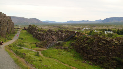
So what does all this mean? Well, as I descended into the park I noticed large and abrupt rock cliffs on either side which turned out to be the two tectonic plates of the Mid-Atlantic Ridge. This is a common view. Sadly the plates are too far apart to do the "continental splits" (one foot in America and the other in Europe). Here's one of the plates (the American one I think).
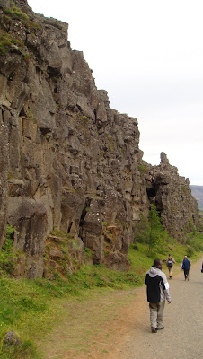 Nothing like seeing geology first hand! Of course if this isn't your thing there are plenty of rivers in the vicinity as well.
 Here's one I particularly liked. My camera couldn't capture it but there are coins at the bottom representing all kinds of currencies. Apparently this is a popular spot for people to make wishes.
 Of course I'm smiling...I recently walked through two tectonic plates!
For extra pictures, click here, here, and here.
Geysir
Calling the area Geysir is actually a misnomer; technically it should be referred to as the Haukadalur geothermal area (which contains many geysers of various sizes). My guess is this was too difficult for tourists so they call the whole thing "Geysir" for simplicity. This probably used to make sense because Geysir is the name of what used to be the largest and most predictably erupting geyser. Unfortunately Geysir is no longer regularly active and just sits there, but the name remains. The current "star of the show" is Strokkur which erupts to a height of about 70 feet (20 meters) every 5-10 minutes. By comparison, Old Faithful in Yellowstone averages about 130 feet (40 meters) every 30-100 minutes. Geysir used to blow water as high as 260 feet (80 m); too bad I missed that show!
This is what the area looks like. FYI - this is a lot of tourists by Icelandic standards. The geyser in the photo is Strokkur (the current active one).
 And here it is when it starts to erupt...
 And it keeps going...
 I was lucky to get a picture with it erupting. Many thanks to my photographer who was forced to remain poised for several minutes.
Gulfoss
This is one of the largest and most breathtaking waterfalls in the country. Here's a shot from up above looking down into the valley. Notice how small the people along the trail and the ridge on the left-hand side look.
 The view if you turn around while coming down the trail. The previous picture was taken pretty close to where those people on the ledge are standing.
 And this is what it looks like if you get a closer look at the falls.
 More of the good stuff.
 As usual, proof that I was actually there...
Þingvellir (pconounced Thing-vellir)
This is arguably the most important historic site in the country. Iceland likes to brag it houses one of the oldest parliaments in the world, and Þingvellir is where all the ancient people met annually starting in 930 AD. All kinds of disputes and duels were settled, and criminals were also punished. Supposedly there still exists a pool named Drekkingarhylur which is where female lawbreakers were drowned (I did not know about this until after and am unsure if I saw it).
As you might imagine, this place has all kinds of history. A couple of highlights: they declared themselves Christian in 1,000 AD, and celebrated their independence from Denmark in 1944. Here is a shot of the area.
 And another.
 Another cool fact about the area is that it visibly shows the reason why Iceland exists. What do I mean? As we all know, the nation is a tiny island alone in the Atlantic ocean. But beneath the country also sits two tectonic plates which are the source of all the geothermal, volcanoes, and earthquakes which characterize the country. Called the American and Eurasian, they are slowly pulling apart from each other at a pace of ~2 centimeters a year. As this happens, lava erupts up from the center of the Earth to form new rock and geologic formations. I like to think this is kind of like when you pull a pimple apart and stuff comes out.
NOTE: This is my pathetic attempt to explain a very important geologic process called "divergent boundaries". Please feel free to read a better (albeit less entertaining) explanation here.
So what does all this mean? Well, as I descended into the park I noticed large and abrupt rock cliffs on either side which turned out to be the two tectonic plates of the Mid-Atlantic Ridge. This is a common view.
 Sadly the plates are too far apart to do the "continental splits" (one foot in America and the other in Europe). Here's one of the plates (the American one I think).
 Nothing like seeing geology first hand! Of course if this isn't your thing there are plenty of rivers in the vicinity as well.
 Here's one I particularly liked. My camera couldn't capture it but there are coins at the bottom representing all kinds of currencies. Apparently this is a popular spot for people to make wishes.
 Of course I'm smiling...I recently walked through two tectonic plates!
For extra pictures, click here, here, and here.
No comments:
Post a Comment